

Modern maps make borders look permanent and rational. Lines appear clean, precise, and authoritative. They suggest order, sovereignty, and control. In Asia, these lines hide a deeper truth. Most Asian borders were not drawn to reflect how people lived, moved, or identified. They were drawn to serve empire.
Asian borders were designed for administration, extraction, and military convenience. They prioritized imperial efficiency over human continuity. When these borders became the foundations of modern states, they carried conflict within them.
Before colonial rule, much of Asia did not organize space through fixed borders. Authority flowed outward from centers rather than stopping at rigid lines. Empires overlapped. Frontiers shifted. People moved, traded, intermarried, and shared culture across regions without needing passports or legal definitions.
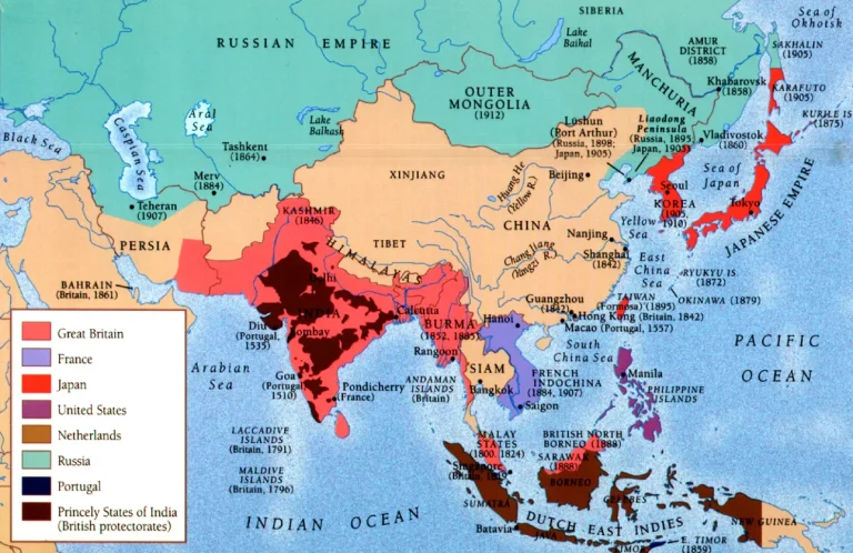
Source: Colonial-era map showing imposed borders across Asia
Political control was relational rather than territorial. Allegiance mattered more than location. Identity was layered rather than exclusive. This flexibility allowed diverse societies to coexist without demanding uniformity.
Colonial empires disrupted this logic. European powers required clear boundaries to tax, govern, and defend territory efficiently. Borders transformed from zones into lines. Maps replaced lived geography.
These lines were often drawn far from the land itself. Decisions were made in colonial offices, guided by surveys, treaties, and strategic calculations. Rivers, mountains, and trade routes mattered only insofar as they simplified control. Ethnic groups, languages, and historical ties were secondary.
In India, colonial boundaries unified vast diversity under a single administrative unit. When independence arrived, that unity fractured violently. Partition divided communities that had lived together for generations. Borders became instruments of trauma.
In Southeast Asia, colonial borders sliced through cultural zones that predated European arrival. Kingdoms were divided. Trade networks were severed. Communities found themselves separated by newly invented nations.
India–Pakistan border shaped by colonial partition
The same pattern repeated across Asia. Lines were drawn to separate rival empires, not to preserve social coherence. Buffer zones were created where people lived. Strategic depth mattered more than consent.
When colonial rule ended, these borders remained. New states inherited imperial maps because redrawing them risked endless conflict. What was temporary became permanent by necessity.
Independence did not reset borders. It froze them. States formed around inherited lines, regardless of how poorly those lines reflected reality. National identity was built after borders, not before them.
This inversion created fragility. Governments struggled to integrate diverse populations forced into shared political space. Minorities questioned legitimacy. Peripheral regions resisted control. Borders became contested symbols rather than accepted facts.
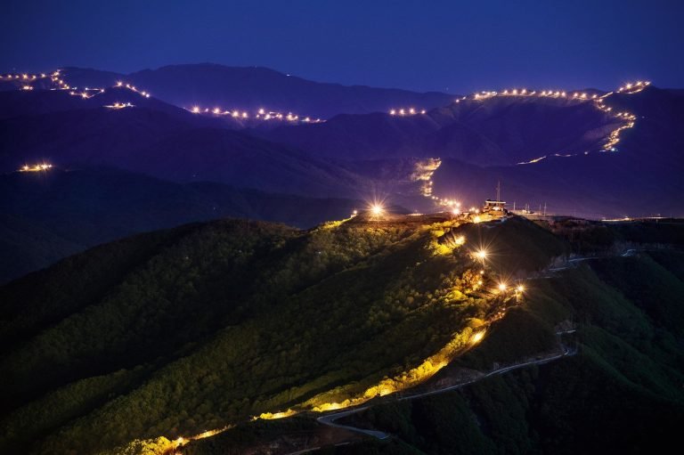
Aerial view of the Korean Demilitarized Zone
In Korean Peninsula, division followed this imperial logic. External powers drew lines to manage influence, not to reflect historical unity. The result was a border that institutionalized conflict rather than resolving it.
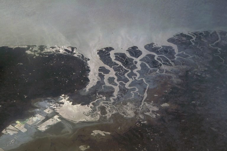
In Kashmir, imperial withdrawal left behind an unresolved frontier. Competing claims hardened into militarized borders. The line itself became the conflict.
Borders designed for empire rarely settle because they were never meant to. They were tools of containment, not reconciliation. When empires left, the logic of control remained embedded in the map.
These borders shape daily life in subtle ways. Families live divided by citizenship. Languages cross borders while laws do not. Trade routes exist on one side and disappear on the other. Movement becomes politicized.
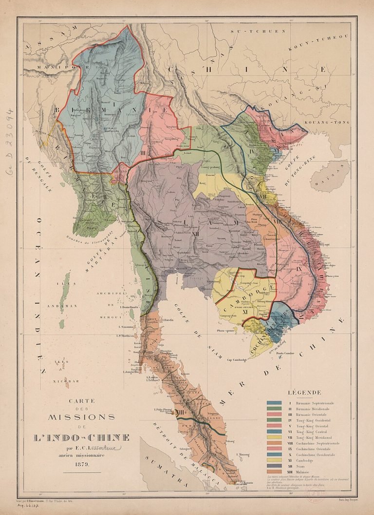
Colonial boundary lines across Southeast Asia
Traveling across Asia reveals this dissonance. Markets feel continuous across borders that maps insist are absolute. Cultural familiarity persists where legal separation dominates.
Borders also shape memory. Conflicts are narrated as national rather than historical. Violence is framed as defense of territory rather than consequence of imposed lines. History becomes simplified to justify present boundaries.
The persistence of border conflict in Asia is not evidence of ancient hatred. It is evidence of modern cartography imposed without consent.
Asian borders were drawn for empire because empire required clarity, speed, and dominance. People required flexibility, negotiation, and time. Empire won the map. People inherited it.
Understanding Asia today requires reading borders as historical artifacts, not natural facts. These lines are not neutral. They carry decisions made under unequal power.
Asia’s borders remain unstable not because Asia resists order, but because the order imposed ignored lived reality.
The map is not the territory. In Asia, it never was.
Comment (0)